A fragment of Spanish olive jar found during our excavations in advance of Edinburgh’s Trams extension reveals that this mediterranean luxury item was imported into Leith during the sixteenth-seventeenth centuries.
But not for cooking!
Rather it was used by apothecaries for medicinal treatments and for soap-making.
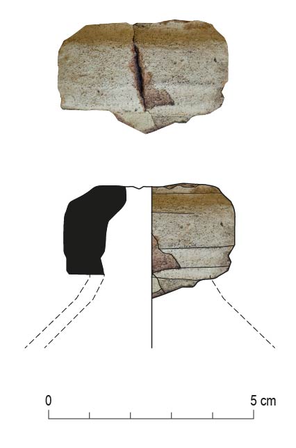
Sherd of Spanish olive jar recovered from GUARD Archaeology’s excavation in Leith
Spanish vessels and olive jars in particular have been recovered from other sites in Leith and Edinburgh and generally date to the sixteenth or seventeenth century. Olive jars are quite distinctive in shape and colour – they have a red/pink sandy fabric with an off-white to buff coloured slip on the exterior. A near complete vessel was found in 1984 at Newark Castle in Port Glasgow.
Trading during this period was heavily influenced by politics (as it is nowadays) and attempts were made by the Scottish Kirk to prohibit trading with Habsburg Spain and its dominions at the end of the sixteenth century. However, trade was restored a few years later and a regular trade was in place by the second half of the seventeenth century with Glasgow as the main port.
This trade carried on well into the following centuries, as evidenced by the collection of nineteenth century olive jars in Edinburgh Museum.
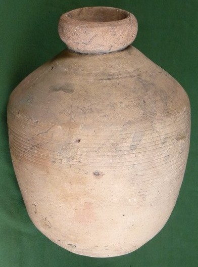
A seventeenth-century ‘botija perulera’ from Seville. The egg-shaped botija was the most common form of olive jar. Milartino, CC BY-SA 3.0 <https://creativecommons.org/licenses/by-sa/3.0>, via Wikimedia Commons
Other imported ceramics, evidencing trade with other parts of mainland Europe, include Rhenish stonewares (from the Rhineland of Germany) and cooking vessels from the Low Countries (Netherlands). Large ports like Rotterdam were used by Scottish merchants to buy these wares, and probably buying goods from Spain too when regular trade was prohibited.
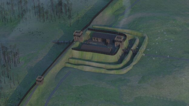
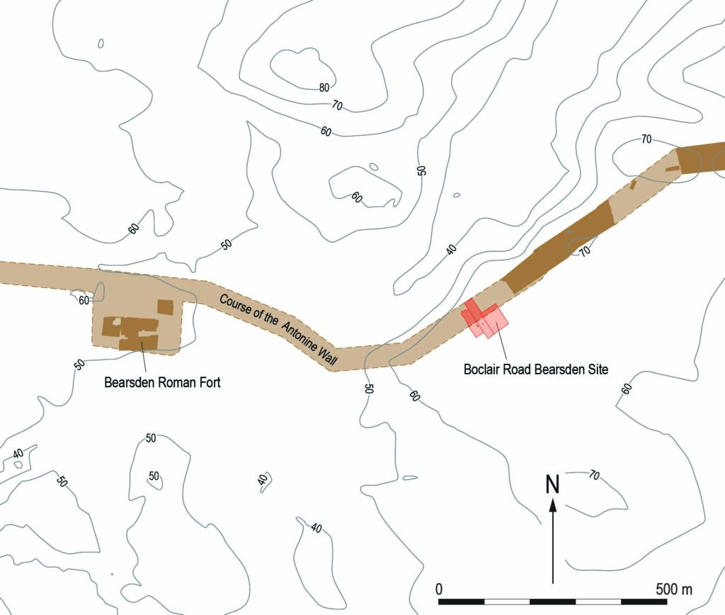
Newly published research by GUARD Archaeology has revealed how a hitherto unknown Antonine Wall Roman fortlet was discovered beneath the back gardens of Bearsden.
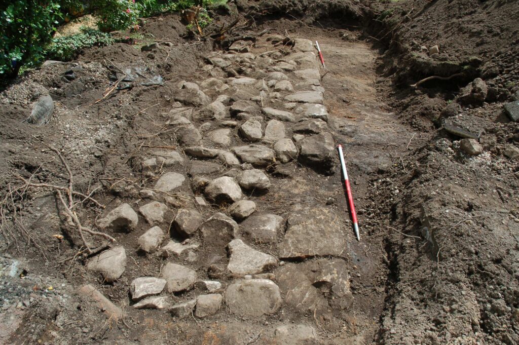
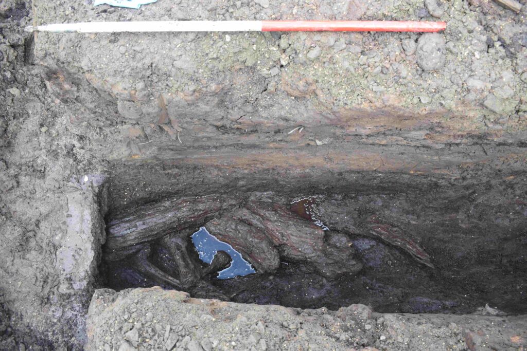
Archaeological investigations within the gardens of three adjacent residential properties in Bearsden in 2017 revealed the stone foundations of a turf rampart. The archaeological work was funded by individual landowners in advance of development and was required as conditions of planning consents by East Dunbartonshire Council.
Historic Environment Scotland identified the investigations as a rare but important opportunity to discover more information about this particular area to the south of the World Heritage Site of the Antonine wall. Historic Environment Scotland subsequently commissioned further excavation which revealed a parallel ditch containing peat deposits, wood and vegetation, and also a geophysical survey which revealed stone structures, likely surviving fragments of the Antonine Wall itself.
What made these discoveries significant was that both the kerbed stone base and its parallel ditch lay perpendicular to the line of the Antonine Wall that crosses this part of Bearsden.
Wood from the bottom of the ditch was radiocarbon dated to AD 127–247 and therefore within the period of use and immediate aftermath of the Antonine Wall. Two sherds of Roman pottery were also subsequently found beneath the stone base.
The Antonine Wall was built in the years following AD 142 by the Roman Army on the orders of their emperor Antoninus Pius (hence its name). Cutting Scotland in two, it separated the conquered Britons of the south from the free Britons to the north. Unlike Hadrian’s Wall, which was built of stone, the Antonine Wall was constructed of turf set onto a stone base. But little more than 20 years after it was built, sometime in the AD 160s, the Romans retreated back to Hadrian’s Wall.
This fortlet lay on an area of high ground right next to the Antonine Wall. It had commanding views over the landscape, particularly to the north, which was beyond Roman control, and was also intervisible with the larger Roman fort at Bearsden which lay close-by to the west on lower lying ground. This suggests that the fortlet was an integral part of the Roman Wall defences which included forts along its length along with smaller fortlets like this, where small detachments from the larger forts were posted to keep an eye out.
Specialist analysis of the botanical and fossil beetle evidence from the bottom of the ditch revealed that when the fort was built, the surrounding landscape was open pasture with areas of partially cleared woodland, mainly alder, hazel and willow, with lesser amounts of oak and birch. Grasses were present within the cleared areas.
The work within the three gardens in Bearsden has revealed how important the planning process is to archaeological investigation and the discovery of new sites. Given their location and date, the archaeological remains discovered in the back gardens of Boclair Road are related to the Antonine Wall and it would therefore seem that the stone base supported a turf wall and the ditch was a section of the perimeter ditch around a hitherto unknown Roman fortlet.
ARO65: Discovery of an Antonine Wall Roman Fortlet at Boclair Road, Bearsden by Maureen Kilpatrick, with contributions by Michael Bamforth, Nysa Noelle Loudon, Coralie Mills, Susan Ramsay, Katharine Warden and Nicki Whitehouse is freely available to download from Archaeology Reports Online.
GUARD Archaeology’s work in bringing two Scottish Bronze Age Hoards to light has been nominated for Current Archaeology’s Research Project of the Year Award 2026.
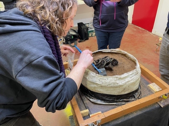
GUARD Archaeology led the post-excavation analyses of the Carnoustie and Rosemarkie hoards undertaken by experts drawn from across Britain including National Museums Scotland, the universities of Glasgow, Stirling, Bradford and Exeter, various independent specialists and GUARD Archaeology itself.
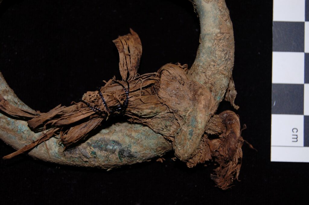
Through careful minute analysis of every strand of evidence, the organic remains as well as the metals, an enormous amount was revealed about the people who buried these hoards at the end of the Bronze Age.
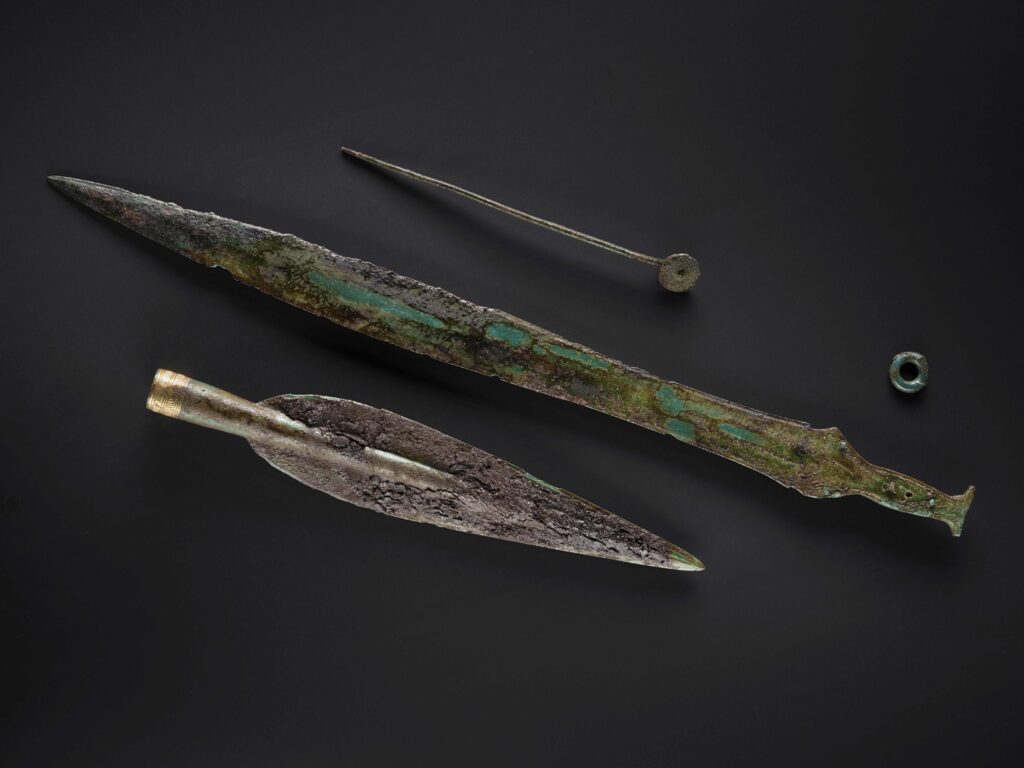
The post-excavation analyses of finds recovered from Carnoustie and Rosemarkie revealed exceptional archaeology.
The organic remains such as the Carnoustie sword scabbard enabled radiocarbon dating of the Carnoustie hoard to 1118-924 BC, earlier than when traditional typologies would place it. While tree bast used to tie many of the Rosemarkie bangles together provided a secure radiocarbon date for the burial of the Rosemarkie hoard: 894-794 BC, at the very end of the Bronze Age.
The metallurgical analyses of both hoards revealed the extensive exchange networks with southern Britain, Ireland and the continent, from which Late Bronze Age metalworkers in Scotland ultimately sourced the materials they shaped into precious objects.
Intriguingly both hoards were buried close to contemporary Bronze Age settlements, leading the GUARD Archaeologists to examine the reasons why these hoards were buried in the first place. Unlike founders’ hoards or metalworkers’ stashes of damaged objects and fragments that could be recycled, or votive hoards of deliberately broken objects thrown into watery places with no chance (or apparent desire) of recovery, the Rosemarkie and Carnoustie hoards contained treasured items that were collected together, wrapped, and neatly buried for safekeeping close to a settlement where they could be guarded and easily retrieved when the time came.
The question, then, is not so much why they were buried, but why the time never came for these Bronze Age communities to retrieve their valuable belongings.
The excavation reports – ARO60: Neolithic timber halls and a Bronze Age settlement with hoard at Carnoustie, Angus by Beverley Ballin Smith, Alan Hunter Blair and Warren Bailie; and ARO62: ‘A Hoard, Spear Moulds and a Bear, Oh my!’ a Late Bronze Age Settlement at Greenside farm, Rosemarkie by Iraia Arabaolaza, Rachel Buckley, Sam Williamson and Alun Woodward – are both freely available to download from Archaeology Reports Online.